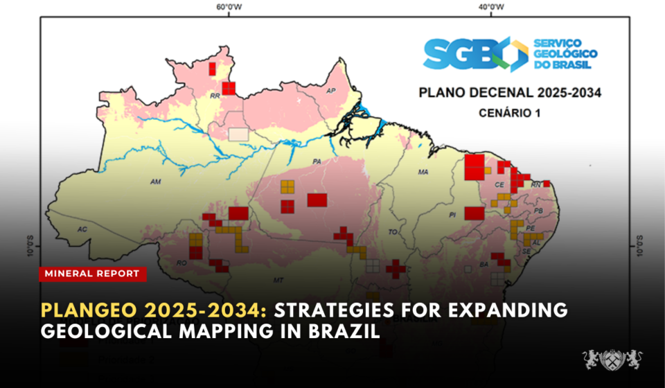
With the purpose of strengthening the country’s geological knowledge base and driving investments in mineral exploration and research, the federal government launched the PlanGeo (Decennial Plan for Basic Geological Mapping and Mineral Resource Survey) on March 13, 2024.
The plan aims to identify priority areas, establish measurable goals, and continuously monitor geological mapping and mineral resource survey activities across the national territory.
The creation of PlanGeo coincides with the launch of the Geological Mapping Platform by the Brazilian Geological Service (SGB) during the PDAC 2024 event.
Inácio Melo, the president of SGB, emphasizes that the platform:
“Not only simplifies access to mappings conducted over more than 50 years but also ensures greater transparency for ongoing projects and predictability of our actions.”
The focus of PlanGeo is to enhance knowledge about minerals related to energy transition and food security, recognizing Brazil’s geological potential to become a leader in supplying these commodities.
According to Valdir Silveira, the director of Geology and Mineral Resources at SGB, the Geological Mapping Platform presents the “State of the Art” in geological mapping across different reference scales, ensuring easy and timely access to project outputs developed over the years.
The main premises adopted in the 2025-2034 planning are as follows:
- Maintenance of the 1:250,000 and 1:100,000 scales as the primary references, with flexibility for more detailed mapping (1:50,000 and 1:25,000) based on demands during the period.
- Expansion of 1:100,000 cartography in mineral provinces, mining districts, and areas with high potential for new mineral discoveries.
- Expansion of 1:250,000 cartography in sectors with lower geological knowledge, especially in the inner portions of the Amazon and Phanerozoic sedimentary basins.
- Selection and prioritization of mapping areas based on geological interest, without rigid conceptual restrictions for Amazonian or non-Amazonian areas.
- Exclusion of large areas with restricted access, such as Indigenous Lands and Full Protection Conservation Units, from the prioritization process.
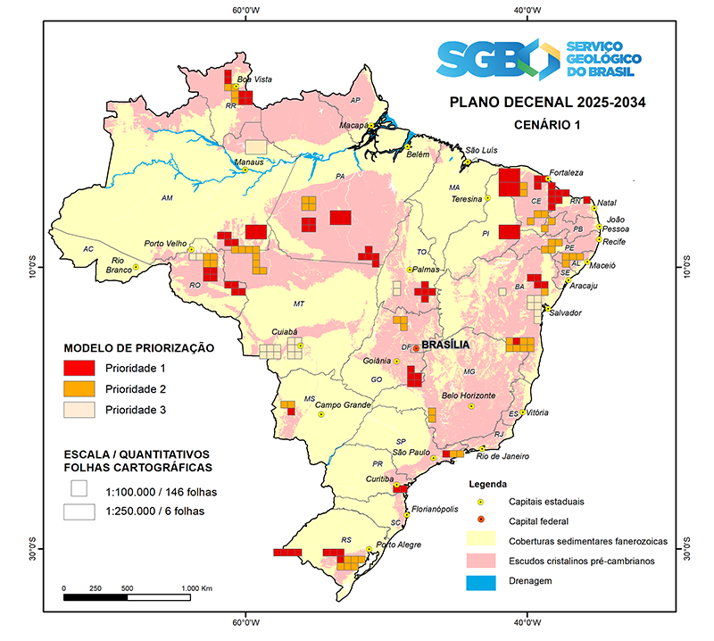
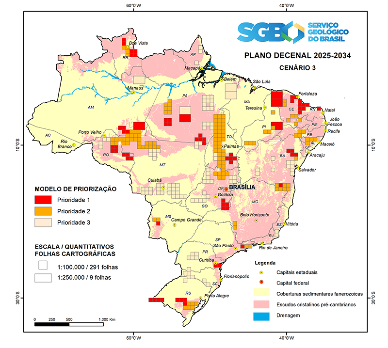
The decennial planning considered three scenarios for expanding geological mapping, taking into account the operational capacity of SGB and the available budget. These scenarios range from 150 to 300 mapped cartographic sheets, reflecting different levels of investment and expansion of the country’s geological coverage.
- Scenario 1: Considers the current operational capacity for systematic geological mapping, considering existing demands and the average recent budget allocation for geological cartography projects. In this scenario, 150 cartographic sheets are planned, with 70 sheets already indicated as Priority 1 and currently being worked on at various stages of project evolution, some initiated in 2024 and concluding in the coming years.
- Scenario 2: Adds 50 sheets, totaling 200 cartographic sheets for systematic mapping at the reference scales.

- Scenario 3: Envisions the mapping of 300 cartographic sheets, with an additional 100 sheets compared to Scenario 2.
PlanGeo is seen as a continuation of the previously launched 2030 Mining Plan, organizing and transparently providing all planning information related to the advancement of mapping, aerogeophysics, and geochemistry.
Source: sgb.gov – Brasil Mineral